Xanten Day
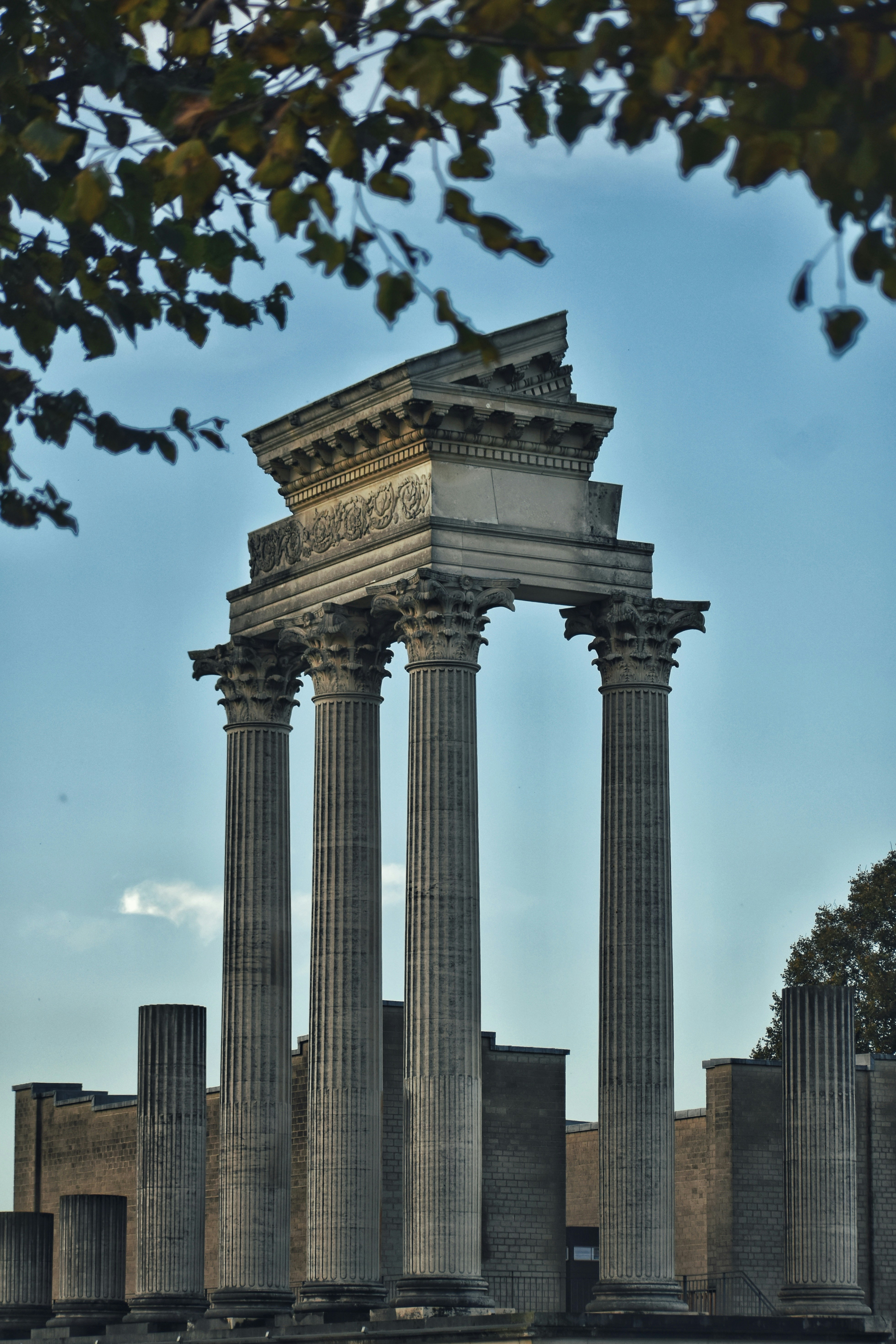
A Sunday in Xanten
We’re heading to Xanten for the day, walking through the old centre and spending a Sunday somewhere outside our usual campus bubble.
We’re going to Xanten
There’s no Study & Chill ticket or booking for this trip. Just meet us at the meeting point and come with us.
A city that makes more sense when you follow the water
Xanten can look like a quiet little town on the Lower Rhine today. But its location tells a much bigger story.
For centuries, the Rhine was the reason this place mattered. It was a border, a transport route, a source of trade and eventually a force that changed Xanten's fortunes simply by changing its course.
And that story is still visible in the landscape. Around Xanten you find the present Rhine, old Rhine channels, wetlands, former river landscapes and large lakes. Then, between all that water, you have two cities from completely different periods: the remains of a Roman metropolis and the medieval Xanten we walk through today.
Before Xanten, there was a Roman city
Nearly 2,000 years ago, this was not a small German town.
The Romans established one of their most important centres on the Lower Rhine here. Around the beginning of the 2nd century, Emperor Trajan gave the settlement the status of a Colonia: Colonia Ulpia Traiana.
That was a big deal. In the Roman province of Lower Germania, only Xanten and Cologne held the prestigious title of Colonia. The city covered around 73 hectares and was laid out deliberately with straight streets crossing in a rectangular grid.
At its centre stood a forum. Around it were temples, public baths, houses, workshops and an amphitheatre. Around the city stood walls and gates. Around 10,000 people could live here.
So when you see the reconstructions at APX, don't imagine an isolated Roman ruin. Imagine an actual city.
The Rhine was basically the motorway
The location was not accidental.
The Rhine ran beside the Roman city and formed part of the Lower Germanic Limes — the frontier of the Roman Empire. But a frontier did not mean an empty line separating two worlds. The river was also one of the great transport routes of the Roman provinces.
Ships could move people, building materials, food and goods along the river. Xanten had its own harbour, connecting the city and the nearby Roman military presence to that network.
In fact, the Roman settlement around Xanten became the second-largest urban centre in Lower Germania after Cologne. For the people living here, the Rhine did something similar to what major railways, motorways and ports do for cities today: it connected them to a much larger economic world.
A harbour where there is no harbour today
This is one of the strange things about Xanten.
Stand around the Archaeological Park today and it is easy to forget that part of the Roman city once faced a working river harbour. Archaeologists have found extensive evidence of the harbour installations, and the Roman harbour at Xanten is one of the best researched Roman harbour sites in the German provinces.
But rivers move.
Channels fill with sediment, bends migrate and landscapes that once sat beside flowing water can eventually find themselves inland. Even during the Roman period, the harbour increasingly suffered from silting.
That changing relationship with the Rhine becomes one of the recurring themes of Xanten's history.
The strange thing about APX: the Roman city never became the modern one
This is what makes Xanten unusually interesting archaeologically.
In many old European cities, later generations simply built on top of the Roman city. Streets, houses and cellars cover what came before.
Here, the medieval centre developed beside the Roman city rather than completely covering it.
That is why today an enormous part of Colonia Ulpia Traiana can form the LVR-Archaeological Park Xanten — Germany's largest archaeological open-air museum.
Inside, reconstructed buildings and surviving foundations mark the old Roman street plan. There is an amphitheatre, the Harbour Temple, Roman houses, city gates and the LVR-RömerMuseum.
And archaeology here isn't finished. Excavations and research are still continuing beneath the fields.
Going earlier? This is where APX fits into the day
Our main group arrives in Xanten at 13:49, but you don't have to wait for us.
If the Roman side is what interests you most, travel earlier and spend the morning or early afternoon at the LVR-Archaeological Park Xanten (APX) and the LVR-RömerMuseum.
Then meet us in Xanten afterwards for the shared part of the day. APX is completely optional and organised individually.
Then another Xanten grew beside it
Roman Xanten declined, but the story of the place didn't end.
The medieval settlement developed around the religious centre associated with St. Viktor. Xanten received medieval town rights in the 13th century and developed into a prosperous town connected to regional trade routes.
That is essentially the Xanten we'll explore together: the market square, cathedral, walls, gates and streets of the later town, sitting beside the footprint of a much older Roman city.
St. Viktor: the building that dominates Xanten
You don't really need directions to find Xanten Cathedral. Its towers dominate the old centre.
The St. Viktor Cathedral grew over centuries on a site connected with the Christian tradition surrounding the martyr Viktor. The church and the religious community around it became one of the anchors around which medieval Xanten developed.
So the cathedral isn't simply another old building to photograph. It represents the centre of the town that emerged after the Roman city had disappeared.
Roman Xanten had its temples, forum and monumental public buildings. Medieval Xanten organised itself around a very different centre. The two sit almost next to each other.
Market square, walls and the Klever Tor
Around the cathedral is the old town we'll actually walk through. The market square forms the social centre, while sections of Xanten's medieval fortifications still shape the edges of the historic centre.
One of the best surviving pieces is the Klever Tor, the medieval double gate on the northern side of the old town. Nearby you'll also find surviving towers and the Kriemhildmühle along the old fortification line.
When you're walking here, look at the shape of the centre rather than only individual buildings. Xanten still has a remarkably readable historic core: gates and walls around the outside, the cathedral rising from within, and the market at its heart.
And then the Rhine moved
This might be the most important part of Xanten's story.
The Rhine has never been a perfectly fixed blue line on a map. Across the flat Lower Rhine landscape, its channels and bends have shifted considerably over the centuries.
For a trading town, that matters.
Medieval Xanten had benefited from its position near important routes. But as the Rhine shifted eastward, the town lost direct access to one of its most important transport connections. By the 16th century, that loss contributed to Xanten's economic decline.
Today the main Rhine lies roughly two kilometres from the historic centre. In other words, when you're standing in quiet little Xanten, you're looking at a place whose importance was once much more directly tied to one of Europe's great rivers.
The river left fingerprints everywhere
Look at a map around Xanten and suddenly there is water everywhere.
Some of it tells the story of the Rhine itself: old river channels, floodplain landscapes and wetlands still reveal how dynamic this landscape has been.
South-east of the town, the Bislicher Insel sits inside an old Rhine loop. Despite the name, it isn't really an island anymore. The Rhine was straightened here around the end of the 18th century, leaving the former channel behind as part of today's Xantener Altrhein.
The area is now a large protected floodplain landscape with old water channels, meadows, wetlands and important habitats for birds. During Rhine floods, parts of the landscape can still take in water.
So even where the river no longer flows, you can still read where it used to be.
And those enormous lakes?
They look natural on the map. They aren't.
The Xantener Nordsee and Xantener Südsee were created through large-scale gravel extraction. Each covers roughly 110 hectares, and today the two lakes are connected by a channel.
What used to be an extraction landscape has become one of Xanten's major recreation areas, with harbours, sailing, water sports, beaches and paths around the water.
There is even a modern Hafen Xanten on the Südsee.
Which gives the story a nice little circle: Roman Xanten had a harbour on the Rhine nearly two thousand years ago; today's Xanten has another harbour beside a lake created by modern industry. Completely different water, completely different purpose — but water is still shaping how the city lives.
So when we walk through Xanten...
We're basically walking through several versions of the same place.
There is the Roman city built beside an imperial frontier and transport artery.
There is the medieval town of cathedral, market, gates and walls.
There is the Rhine landscape that kept moving around them.
And there is modern Xanten, where former gravel pits became lakes, old Rhine channels became nature reserves and an abandoned Roman city became one of the largest archaeological attractions in Germany.
That's what makes Xanten worth more than a quick photo at the cathedral. Once you know what you're looking at, the whole landscape starts connecting.
Want to start earlier?
You can.
If you want more time in Xanten, you can travel there earlier and use the morning or early afternoon for the LVR-Archaeological Park Xanten (APX), the Roman Museum or anything else you want to see.
You don’t have to take our connection from Kamp-Lintfort. Just meet us directly in Xanten later for the shared part of the day.
We’ll share the exact Xanten meeting point with the group.
Going together from Kamp-Lintfort
We’ll meet at HSRW Kamp-Lintfort at 12:15 and head to Xanten together from there.
- Meeting: Sunday, 11 October at 12:15
- Meeting point: Hochschule Rhein-Waal, Kamp-Lintfort Campus
- Departure from Neues Rathaus: 12:29
- 12:15 — Meet at HSRW Kamp-Lintfort
- 12:29 — Neues Rathaus, Kamp-Lintfort
- 12:44 — Rheinberg Bahnhof
- 12:56 — Rheinberg → Xanten
- 13:49 — Arrival in Xanten
The plan
- Meet at HSRW Kamp-Lintfort at 12:15
- Travel to Xanten together
- Meet anyone who travelled earlier directly in Xanten
- Explore the historic centre together
- Walk around Xanten and see where the afternoon takes us
If you’re going earlier for APX or the museums, you can simply join us in Xanten afterwards.
Good to know
- There is no Study & Chill registration for this day.
- Bring whatever ticket or travel pass you normally need for your journey.
- APX, museums and other paid attractions are optional and organised individually.
- If you go to Xanten earlier, you can meet us there later.
- Wear comfortable shoes.
Questions or joining us directly in Xanten? Keep an eye on the Study & Chill group for updates.